

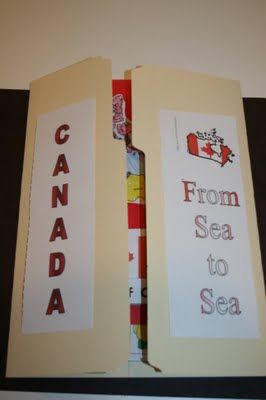
Lapbooks are a great way to integrate hands-on learning into your lessons! Use this as a introduction to your Canada unit, an end-of-unit project, or even a partner project. Students will conduct research and then use the lapbook to: - identify the provinces and territories - identify places on a map - write about the meaning of the flag - describe four Candian symbols - write facts about three famous Canadians (student's choice) - write other interesting facts about Canada Lapbooks make great displays for Parent/Teacher conferences, or a great addition to student portfolios! Thanks for your interest, Shelley Gray

Help kids learn the provinces and capitals with this super-cool printable map puzzle!

Resources, links, printables, and some funny stories about what happened the week I decided to take my kids on a pretend "trip" to Canada to learn all about Canadian land, history, and culture.

Ready to learn about the second largest country in the world? Grab these printable Canada Coloring Pages to learn about Canadian wildlife, Mounties,hockey, and more!

For anyone who knows us or has been reading my blog for a while, you probably aren't surprised that Canada was chosen for our geography fair project and you probably know who's idea it was. Colin wants to live in Canada, where he imagines he'd be surrounded by hockey and find outdoor ice rinks on every corner. Since it was our first geography fair, I thought it would be best if they just did one country together. Colin immediately said Canada, but the girls weren't too thrilled with that idea. They named other countries, but never seemed set on one so I talked them into doing Canada. I figured Colin would do more of the work since he's older and should do something he's interested in. We used the Download N Go (DNG) study, Expedition Canada. From this we got to watch lots of videos showing different parts of Canada. We learned about a different animal each day, some places there, inventions, history, popular sports, Canadian cities, geography, and holidays. Some of the books we read Caleigh made this beaver, a national symbol of Canada, and this totem pole, which were made by the First Nations peoples. Lego Creations: Colin made the CN Tower and Caleigh made an inukshuk, both of which we learned about in the DNG study. In addition to DNG, we also used Homeschool Share's Canada lapbook and a Canada mini lapbook from Fortunately for You for our lapbook. I think this is the first time we've ever done an actual lapbook. We usually just add the mini books to our notebooks, but I wanted something they could display at the fair this time. We made maple cookies with real maple syrup. You can find the recipe we used here. Kids at the geography fair. Along the bottom of the table, we taped coloring pages for each of the provinces and territories.The kids spent a lot of time coloring them. Display board: It was Colin's idea to use black and red. Caleigh came up with using maple leaves under the letters in Canada. On the bottom right is a Mountie paper craft that Molly put together. Also on the board: map of Canada, map of North America, flag, popular sports, major industries, major crops, information about what the word Canada means, languages, holidays, animals, and Levi from Children Just Like Me. On the right, we brought along some of the inventions from Canada. On the left toward the front of the table is a French Canadian counting book. In this picture, you can see Colin's hockey helmet, a puck, the Lego CN Tower, and a French/English color words matching game. I'm so glad we did the geography fair. It was lots of fun showing our display and seeing everyone else's. The girls and I weren't too excited about doing Canada since it doesn't seem as exciting as some other countries, but we did learn a lot of new things and it ended up being a good study for us. In my previous post, I have some pictures of other projects at the fair and Molly getting a henna tatoo.

TONS of fun Canada themed activities to celebrate Canada! These hands on activities were done during a Canada unit with Grade One, Grade Two, and Grade Three. #Canada #gradeone #1stgrade #2ndgrade #3rdgrade #gradethree #gradetwo #canadaunit #socialstudies #allaboutcanada

"Travel” to Canada with this fun Canada Activities Pack for K-1. We hope they will be useful in centers or groups work when you learn about Canada.

Hello my friends! Here in Ontario, we have one week left of classes. At the end of the school year, I like to take some time to discuss Canada Day with my students, and do some fun literacy review with the no-prep printables below! For the age group I teach, their perceptions of Canada Days past can be quite entertaining: Canada Day is clearly a memorable experience for even our youngest students, whether it be of fireworks, time with family or friends during the day. This is a great time to review what we have learned about the structure of stories. Whether
For anyone who knows us or has been reading my blog for a while, you probably aren't surprised that Canada was chosen for our geography fair project and you probably know who's idea it was. Colin wants to live in Canada, where he imagines he'd be surrounded by hockey and find outdoor ice rinks on every corner. Since it was our first geography fair, I thought it would be best if they just did one country together. Colin immediately said Canada, but the girls weren't too thrilled with that idea. They named other countries, but never seemed set on one so I talked them into doing Canada. I figured Colin would do more of the work since he's older and should do something he's interested in. We used the Download N Go (DNG) study, Expedition Canada. From this we got to watch lots of videos showing different parts of Canada. We learned about a different animal each day, some places there, inventions, history, popular sports, Canadian cities, geography, and holidays. Some of the books we read Caleigh made this beaver, a national symbol of Canada, and this totem pole, which were made by the First Nations peoples. Lego Creations: Colin made the CN Tower and Caleigh made an inukshuk, both of which we learned about in the DNG study. In addition to DNG, we also used Homeschool Share's Canada lapbook and a Canada mini lapbook from Fortunately for You for our lapbook. I think this is the first time we've ever done an actual lapbook. We usually just add the mini books to our notebooks, but I wanted something they could display at the fair this time. We made maple cookies with real maple syrup. You can find the recipe we used here. Kids at the geography fair. Along the bottom of the table, we taped coloring pages for each of the provinces and territories.The kids spent a lot of time coloring them. Display board: It was Colin's idea to use black and red. Caleigh came up with using maple leaves under the letters in Canada. On the bottom right is a Mountie paper craft that Molly put together. Also on the board: map of Canada, map of North America, flag, popular sports, major industries, major crops, information about what the word Canada means, languages, holidays, animals, and Levi from Children Just Like Me. On the right, we brought along some of the inventions from Canada. On the left toward the front of the table is a French Canadian counting book. In this picture, you can see Colin's hockey helmet, a puck, the Lego CN Tower, and a French/English color words matching game. I'm so glad we did the geography fair. It was lots of fun showing our display and seeing everyone else's. The girls and I weren't too excited about doing Canada since it doesn't seem as exciting as some other countries, but we did learn a lot of new things and it ended up being a good study for us. In my previous post, I have some pictures of other projects at the fair and Molly getting a henna tatoo.

Resources, links, printables, and some funny stories about what happened the week I decided to take my kids on a pretend "trip" to Canada to learn all about Canadian land, history, and culture.

Oh my goodness - how I LOVE spring break!!! The school break is great, don't get me wrong ... but I think what I'm enjoying most is the break from my girls' extra-curricular activities. I have two little dancers and one soccer superstar ... and they keep us RUNNING!!! For the first time in a LONG time, we had NO activities this weekend ... which equals sleeping in ... which equals heaven to me. :) So, with the extra time I've found plus two very rainy days (not complaining - hoping that rain melts some of this snow mountain around me) it gave me the time I needed to finish a couple of projects I've been working on. I've been working on a Canadian Lapbook Project. My class LOVES making lapbooks in our science units, so I thought I'd create one for Social Studies. Provinces and Territories is actually taught in grade 4 in my province, but it's a unit I always review in my class at the beginning of the year because it's SO important to me that the students know all about their country. This lapbook has the students naming the province and territory capitals, population, major lakes and rivers, and exports and imports. They also research natural resources and physical regions of Canada. You can click on any of the pictures to preview this product. I had SO much fun creating the Canadian project, and had such a great reaction from my daughters (who insisted on helping me with the cutting), I decided to create a similar one for the United States. I quickly realized that with 50 states, this was going to be a MUCH bigger lapbook. This lapbook is actually 6 pages (2 file folders). Students will study the state abbreviations, capital cities, state population, date it entered the union, imports and exports, and major lakes and rivers. They will also research famous Americans, natural resources, famous landmarks, climate, highest peaks, and more. It would make an impressive project to display and then send home to the parents! Again, you can click on any of the pictures to preview this product. To celebrate Spring Break, I'm going to giveaway FIVE of these resources. Just leave a comment below stating which one you could use and I'll use the random number generator to choose 5 different names tomorrow. Check back tomorrow evening to see the winners. Happy Monday!! Jen

A simple way to encourage learning in a fun way. Kids will love playing Canada Bingo Game on Canada Day!

Keep the kids busy, and learning, with this fun Canada Day preschool learning package. It's filled with 23 educational pages for preschool to kindergarten!

Deze stevige 24x36" wandkaart beslaat 3000 v.Chr. – heden en toont alle grote rijken, koninkrijken en beschavingen door de geschiedenis heen in een formaat naast elkaar, zodat de kijker snel kan zien hoe verschillende gebeurtenissen op verschillende plaatsen zich tot elkaar verhouden. Er is bewust geprobeerd om de kaart minder eurocentrisch te maken dan andere soortgelijke tijdlijnen en om nieuw ontdekte verbanden tussen vroege beschavingen op te nemen. Gemaakt in een CO2-neutrale faciliteit met behulp van milieuvriendelijke inkten.

Resources, links, printables, and some funny stories about what happened the week I decided to take my kids on a pretend "trip" to Canada to learn all about Canadian land, history, and culture.

Games, activities, printables and more for celebrating Canada Day for kids.

Looking to learn about the great white north, eh? You will love this free printable Canada for Kids reader to color, read, and learn!

This year Kaleb and I have been wandering around the world via books, Little Passports, and various other things we come across in our

Dessin du drapeau du Canada à imprimer pour le coloriage. Le drapeau du Canada comprend trois bandes verticales : une bande rouge, une bande blanche et une bande rouge. La bande blanche, plus large que les deux autres porte en son centre une feuille d'é

Help kids learn about Canada with our free printable Canada themed I spy activity with Canadian pictures to hunt and find.

This vagus nerve and polyvagal therapy cheat sheet provides definitions of the vagus nerve, clarity on what vagal tone is, as well as polyvagal therapy techniques, and guidance on polyvagal check-ins

Profitez d’une liste de ressources sur le thème du Canada. Activités pour enfants, récits à lire à voix haute ou à imaginer, documentaires, il y a tout ce qu’il faut pour un voyage virtuel.

I'm in the middle of my "Symbols of Canada" unit with my Grade 1's. It has been a learning experience for me, as I haven't taught Grade 1 since I was a student teacher, but it has been really fun! I'm enjoying bringing in resources for my kids all about Canada and British Columbia. Last week, I showed them "O Canada" from Ted Harrison, a Canadian painter who recently passed away. I love Harrison's paintings. They are full of colour and his style is so distinctive. As a class, we discussed the images in the book and pointed out Canadian landscapes and symbols. This week, I brought in "S is for Spirit Bear" by G. Gregory Roberts and Bob Doucet. While Ted Harrison's book has a lot of images of Northern Canada, "S is for Spirit Bear" focusses on British Columbia. It is an Alphabet Book of B.C. with beautiful illustrations by Bob Doucet. We live in B.C. and my students could relate to a lot of the images in the book. Anyone who lives on Vancouver Island will recognize the next image of the BC Ferries. I live in Victoria - B.C.'s capital city. We are on Vancouver Island, off the west coast of Canada. My kids were very excited to tell us all about their experiences taking the ferry to Vancouver, to visit family, and to other destinations. We've also been working our way through a Canada booklet I created (that you can download for free here). The booklet has 8 pages altogether, with information about the RCMP, Canadian coins, totem poles, and other symbols. This week, we completed the following page. We discussed the maple leaf and the beaver as important Canadian symbols. We also talked about where we could find these symbols (on money, on the flag, etc.). When the students were finished their page, we made beavers for a class display. I made one as a demo, using heart shapes for the face, nose, and teeth. Their beavers turned out adorable! This is how the display looked when it was finished. I have to say, I was nervous to go down to primary, but it has been a lot of fun. I'm only with this class on Fridays, and I'm sad that we only have 14 Fridays left until the end of the school year. It doesn't seem like much time at all!

Looking for things to do in st john's, Newfoundland? You've come to the right place! We visit St. John's often and this is why we love it!

This All About Canada Country Pack provides an engaging and hands-on learning experience for preschool and primary students. This educational tool helps children learn about geography by exploring Canada, its […]

Whether you are in the US & curious what homeschooling looks like in Canada or new to homeschooling and wondering how to get started, this ones for you!

Explore Canada's geography with StorybardThat's free lesson plans on nature, resources and history with activities including maps and posters for students.

Are you teaching your students facts about Canada? These activity sheets are for kids to learn information about Canada. Map and flag of Canada are included. This resource includes: Canada fact sheet (in color and b/w) Canada blank fact sheet for kids to complete 3-2-1 about Canada activity sheet Canadian flag activity sheet Map of Canada Map of Canada activity sheet (with answer key) Venn Diagram comparing and contrasting Canada and the United States (with answer key) Venn Diagram comparing and contrasting Canada to country of student's choice Check out these other resources: U.S. Symbols Map Skills Thank you for taking an interest in this product. Please FOLLOW ME so you can see more resources that I create. If you purchase this product, please provide feedback. You will earn credits to use on future TpT purchases. Thank you! :) Laurie

Learn about Canada with this unit study. Check out all the resources below to study Canada and grab the FREE printable portion.

Today Tracey from Little Pockets of Bliss is introducing us to her hometown and sharing all the best things to do in Kitchener Ontario!

Image 5 of 62 from gallery of Albert Einstein Education and Research Center / Safdie Architects. Photograph by Pedro Kok

Facebook Twitter Pinterest Canada Day is one of our family’s favourite holidays! We usually celebrate by dressing the part and taking in our local festivities. We attend our community’s pancake breakfast, parade, and fireworks.This year we are having some extra fun by adding some Canada themed activities to our studies as well! Here are some ideas […]
